Petra, vùng đất kỳ quan thiên nhiên của Jordan
Petra được chọn là một trong bảy kỳ quan của thế giới vào đầu thế kỷ 21

Trần Nguyên Thắng/ATNT Tours & Travel
Petra là một vùng núi đồi nằm về phía nam của Jordan, một tọa điểm nối liền giữa hai biển Red Sea (Hồng Hải) và Mediterrean (Địa Trung Hải). Đồng thời, Petra cũng gần như là điểm nối liền của hai lục địa Á Châu (miền Trung Đông) và Phi Châu (bán đảo Sinai). Nhờ vào vị trí thuận tiện như vậy, thời đó Petra trở thành giao điểm về thương mại và văn hóa hết sức quan trọng trong khu vực từ thế kỷ 1 trước công nguyên. Điều này hấp dẫn và thu hút tham vọng của các đế quốc luôn tranh chấp để chiếm giữ vùng đất Petra. Năm 2001 Petra đã được Swiss Corpration New 7 Wonders Foundation chọn làm một trong bảy kỳ quan thế giới.
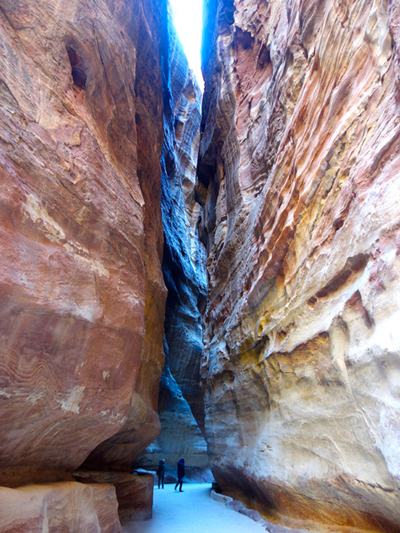 Đoạn Al-Siq hẻm núi hẹp nhất. (Hình: ATNT Tours & Travel)
Petra tuy có một thành phố một nằm trong khu vực du lịch nổi tiếng nhưng lại là thành phố không quá lớn. Cũng có khá nhiều khách sạn nhỏ được xây dựng gần trước cổng vào khu thưởng ngoạn. Những ai thích mạo hiểm và tìm tòi nghiên cứu về Petra thường sẽ chọn ở lại nơi đây vài đêm để tiện cho việc ra vào thung lũng. Từ cổng vào Petra cho đến trước hẻm núi hiểm trở Petra dài khoảng một cây số, du khách lớn tuổi nếu không muốn đi bộ thì có thể cưỡi lừa, ngựa hay lạc đà đi từ cổng đến trước hẻm núi Petra (nhưng khi dùng các dịch vụ này người du khách phải hết sức cẩn thận rõ ràng). Đoạn đường này gọi tên là Bal as-Siq, con đường mòn nối dài hai đầu thung lũng Moses (Valley of Moses) xuyên qua hai ngọn núi Jabal al-Khubtha và Jabal al-Jilf.
Ngoài ra, còn có các con sông ngoằn ngoèo nối tiếp nhau chảy từ Springs of Moses đến Petra. Đoạn đường đi bộ Bal as-Siq này rất đẹp và có nhiều thắng cảnh di tích và thiên nhiên để bạn có thể thưởng ngoạn ở nơi đây.
Đoạn Al-Siq hẻm núi hẹp nhất. (Hình: ATNT Tours & Travel)
Petra tuy có một thành phố một nằm trong khu vực du lịch nổi tiếng nhưng lại là thành phố không quá lớn. Cũng có khá nhiều khách sạn nhỏ được xây dựng gần trước cổng vào khu thưởng ngoạn. Những ai thích mạo hiểm và tìm tòi nghiên cứu về Petra thường sẽ chọn ở lại nơi đây vài đêm để tiện cho việc ra vào thung lũng. Từ cổng vào Petra cho đến trước hẻm núi hiểm trở Petra dài khoảng một cây số, du khách lớn tuổi nếu không muốn đi bộ thì có thể cưỡi lừa, ngựa hay lạc đà đi từ cổng đến trước hẻm núi Petra (nhưng khi dùng các dịch vụ này người du khách phải hết sức cẩn thận rõ ràng). Đoạn đường này gọi tên là Bal as-Siq, con đường mòn nối dài hai đầu thung lũng Moses (Valley of Moses) xuyên qua hai ngọn núi Jabal al-Khubtha và Jabal al-Jilf.
Ngoài ra, còn có các con sông ngoằn ngoèo nối tiếp nhau chảy từ Springs of Moses đến Petra. Đoạn đường đi bộ Bal as-Siq này rất đẹp và có nhiều thắng cảnh di tích và thiên nhiên để bạn có thể thưởng ngoạn ở nơi đây.
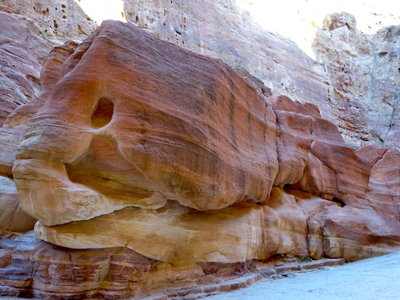 Tảng đá hình cá khổng lồ do thiên nhiên điêu khắc qua thời gian
tại hẻm vực Petra. (Hình: ATNT Tours & Travel)
Những ngọn đồi nhỏ mang màu sắc vàng nâu đỏ vươn cao hai bên đường như nhắc nhở người ta về cái nóng bỏng của sa mạc; những hình dáng cong tròn của đồi núi cho du khách hình dung ra được “đường đi” của gió in lên núi đồi sa mạc qua cả một quãng thời gian cả vài chục ngàn năm. Bên cạnh đó là những hang động nho nhỏ do con người đào xới, không phải để người sống ở mà là những ngôi mộ xưa nơi người chết an nghỉ. Có ngôi mộ đục khắc như hình dạng Obelisk Tomb bên Ai Cập vẫn còn hiện hữu bên đường. Tuy nét đục khắc đơn sơ, không thể nào so sánh được với kiến trúc đền Abu Simbel của Ai Cập nhưng cũng cho người du khách cảm nhận được một nét phảng phất kiến trúc của người Ai Cập cổ xưa (hơn 3,300 năm trước) hiện diện quanh quẩn đâu đó tại Petra.
Trên đường đi vào thung lũng, người ta có thể bắt gặp những tảng đá to lớn Djinn Blocks được bộ lạc Nabataean xưa kia đục khắc theo niềm tin thần linh dân gian Ả Rập từ đầu thế kỷ thứ nhất. Tôi đã gặp những nghệ nhân đến đây, đứng dưới cơn nắng của tiết trời sa mạc tháng hai khá nóng, nhưng vẫn say mê vẽ hình ảnh “không gian của Djinn Block” mà hình như không màng gì đến cái nóng chung quanh.
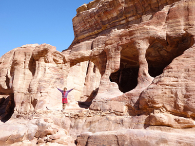 Các hang động được hình thành trong các dãy núi. (Hình: ATNT Tours & Travel)
Nói về hành trình du ngoạn hẻm núi Petra, người ta thường khởi đầu từ điểm Wadi Al Mudhlim (thung lũng Al Mudhlim). Đoạn đường này còn được gọi là As-Siq, dài hơn 1.2km. Trước cửa thung lũng, người ta cho hai chiến binh ăn mặc theo cung cách chiến binh ngày xưa đứng ngay điểm khởi đầu, dáng ra vẻ như là quân lính ngày xưa đứng canh gác, tạo cho du khách hình ảnh tưởng tượng về các trận chiến xưa kia.
Hẻm núi này có khúc chật hẹp nhưng cũng có khúc tương đối rộng, có khúc ánh nắng chui qua được khe núi, có khúc ánh nắng không còn ánh nắng mà chỉ còn ánh sáng bên trên hai vách núi (vì vách núi cao quá). Hình ảnh này khiến tôi nhớ đến hẻm vực núi Antelope Canyon ở tiểu bang Arizona. Tuy nhiên, Antelope Canyon nhỏ hơn hẻm vực Petra rất nhiều. Hai bên con đường ngoằn ngoèo trong hẻm vực Petra là những vách núi cao đến 80m. Tuy hiểm trở như thế nhưng phong cảnh nơi đây lại rất hữu tình. Những màu sắc đỏ hồng vàng nâu trên vách núi, kèm theo màu sắc của đất cát và những hình thể sinh vật mà bàn tay tạo hóa đã vô tình uốn nắn cho các hẻm núi thiên tạo, khiến cho du khách những cảm giác thật lạ lùng bất ngờ.
Vượt qua khỏi hẻm núi As-Siq, du khách bàng hoàng trước một công trình kiến trúc đục khắc vào vách núi tuyệt đẹp hiện ra trước mắt. Đó là một kho tàng bảo vật vĩ đại Petra đẹp nhất của “kinh đô Petra cổ,” có tên là Al-Khazna. Đây có lẽ là một lăng mộ dành cho một vị vua nổi tiếng của người Nabataean, nhưng sau đó lại được dùng như một ngôi đền (temple) làm nghi lễ trong tôn giáo của người dân địa phương. Al-Khazna được xem như là một bảo vật, một kho tàng công trình thiết kế điêu khắc tuyệt hảo của bộ tộc Nabataean vào thế kỷ 1 trước công nguyên. Tôi cho rằng những kiến trúc đền đài bên Ai Cập mà ta thưởng ngoạn đều thua xa so với nghệ thuật đục khắc tinh xảo của ngôi đền Al-Khazna.
Các hang động được hình thành trong các dãy núi. (Hình: ATNT Tours & Travel)
Nói về hành trình du ngoạn hẻm núi Petra, người ta thường khởi đầu từ điểm Wadi Al Mudhlim (thung lũng Al Mudhlim). Đoạn đường này còn được gọi là As-Siq, dài hơn 1.2km. Trước cửa thung lũng, người ta cho hai chiến binh ăn mặc theo cung cách chiến binh ngày xưa đứng ngay điểm khởi đầu, dáng ra vẻ như là quân lính ngày xưa đứng canh gác, tạo cho du khách hình ảnh tưởng tượng về các trận chiến xưa kia.
Hẻm núi này có khúc chật hẹp nhưng cũng có khúc tương đối rộng, có khúc ánh nắng chui qua được khe núi, có khúc ánh nắng không còn ánh nắng mà chỉ còn ánh sáng bên trên hai vách núi (vì vách núi cao quá). Hình ảnh này khiến tôi nhớ đến hẻm vực núi Antelope Canyon ở tiểu bang Arizona. Tuy nhiên, Antelope Canyon nhỏ hơn hẻm vực Petra rất nhiều. Hai bên con đường ngoằn ngoèo trong hẻm vực Petra là những vách núi cao đến 80m. Tuy hiểm trở như thế nhưng phong cảnh nơi đây lại rất hữu tình. Những màu sắc đỏ hồng vàng nâu trên vách núi, kèm theo màu sắc của đất cát và những hình thể sinh vật mà bàn tay tạo hóa đã vô tình uốn nắn cho các hẻm núi thiên tạo, khiến cho du khách những cảm giác thật lạ lùng bất ngờ.
Vượt qua khỏi hẻm núi As-Siq, du khách bàng hoàng trước một công trình kiến trúc đục khắc vào vách núi tuyệt đẹp hiện ra trước mắt. Đó là một kho tàng bảo vật vĩ đại Petra đẹp nhất của “kinh đô Petra cổ,” có tên là Al-Khazna. Đây có lẽ là một lăng mộ dành cho một vị vua nổi tiếng của người Nabataean, nhưng sau đó lại được dùng như một ngôi đền (temple) làm nghi lễ trong tôn giáo của người dân địa phương. Al-Khazna được xem như là một bảo vật, một kho tàng công trình thiết kế điêu khắc tuyệt hảo của bộ tộc Nabataean vào thế kỷ 1 trước công nguyên. Tôi cho rằng những kiến trúc đền đài bên Ai Cập mà ta thưởng ngoạn đều thua xa so với nghệ thuật đục khắc tinh xảo của ngôi đền Al-Khazna.
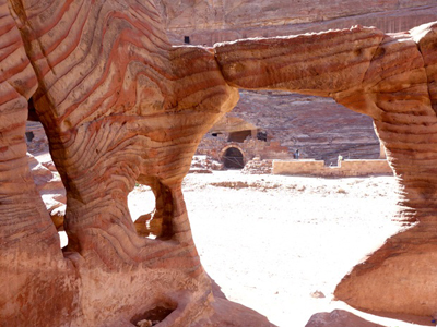 Một hang động màu sắc đá thiên nhiên, từng là nơi trú ẩn của dân vùng thung
lũng Mousa. (Hình: ATNT Tours & Travel)
Các đền đài Ai Cập cho người xem cảm nhận được sự vĩ đại vào thời điểm cách đây hơn 3,300 năm, nhưng công trình kiến trúc Al-Khazna (cao 43m và rộng ngang 30m) lại cho người xem cảm nhận được sự tinh xảo của nghệ thuật đục khắc vách núi của nghệ nhân ở đây. Càng quan sát công trình điêu khắc này người ta càng cảm thấy sự hoàn hảo khéo tay của những người nghệ nhân xưa kia. Chỉ cần xem những cột đá tròn cao lớn được đục khắc kích thước đều nhau cũng đã đủ làm cho người thưởng ngoạn ngưỡng mộ. Al-Khazan không còn mở cửa cho du khách vào thưởng ngoạn như xưa nữa vì Al-Khazan cần được “nghỉ ngơi” và trùng tu trước làn sóng du khách đến đây mỗi ngày mỗi đông.
Khi bạn bước đến kho tàng bảo vật Al-Khazna cũng chính là lúc bạn mới “lò dò” bước đến điểm khởi đầu cho những ai muốn khám phá Petra. Thời gian để bạn khám phá các điểm di tích khác của Petra phải mất ít nhất hai ngày, phải leo núi xuống non. Đây là một vùng thung lũng rộng lớn Mousa, Farasa, As-Siyyagh bao gồm các quần thể đền đài, hang động và các hầm mộ đã được xây dựng khoảng hai ngàn năm và còn tồn tại cho đến bây giờ. Các hang động làm nơi trú ngụ cho người dân ngày xưa màu sắc đẹp rực rỡ của đá làm kinh ngạc du khách.
Các điểm di tích rất đáng xem phải kể đến là “Rạp hát ngoài trời” (The Theatre), Urn Tomb, Palace Tomb và kiến trúc của tu viện đền Ad Deir. Tu viện này là một tuyệt tác kiến trúc điêu khắc khác của Petra. Nhưng muốn đến các nơi đây thì bạn cần phải có chút ý chí tò mò muốn xem và đôi chân còn trong tình trạng ham muốn đi, nhất là “đi nhiều nghỉ ít!” Hẻm núi Petra làm tôi nhớ nhiều đến các chuyện cổ tích ngày xưa của thế giới, nhưng cũng cho tôi cảm nhận được rất nhiều điểm tinh hoa của dân tộc Ả Rập cổ và bàn tay kiến trúc khéo léo của tạo hóa.
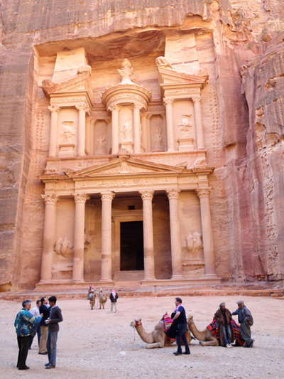 Al-Khazna bảo vật Petra xây từ năm 60BC-50AD (Petra’s Treasury).
(Hình: ATNT Tours & Travel)
Hẻm vực núi không phải chỉ là những thắng cảnh thiên nhiên nổi tiếng, mà còn nổi tiếng với các chiến trận trong lịch sử thế giới. Trong Tam Quốc Chí, Khổng Minh đã dùng “hỏa kế” trong hẻm vực núi Thượng Phương Cốc để tiêu diệt đối thủ Tư Mã Ý, Ý suýt bị thiêu sống, nhưng nhờ trời mưa nên Ý thoát chết. Ải Chi Lăng của Việt Nam vì “lầy lội” nên danh tướng nhà Minh Liễu Thăng mới bị Bình Định Vương Lê Lợi chém! Còn hẻm vực núi Petra của dân Nabataean có “dòng sông lũ” mùa mưa sẵn sàng làm chết đuối quân địch thiếu kinh nghiệm. Tuy nhiên, nếu quân địch kinh nghiệm dày dạn chiến trận thì dân Nabataean phải diệt vong vì địch quân chỉ cần ngăn chận nguồn nước vào thành thì dân trong thành đành phải chịu đầu hàng thua cuộc.
Ngày nay, Petra trở thành một trọng điểm du lịch cho những du khách đến thưởng ngoạn thắng cảnh thiên nhiên và di tích lịch sử của Jordan, nơi chốn đã để lại những công trình tuyệt tác về điêu khắc kiến trúc và những thắng cảnh thung lũng nhiều tầng lớp đá cát hồng vàng nâu đỏ. Petra được chọn là một trong bảy kỳ quan của thế giới vào đầu thế kỷ 21 thì cũng chẳng có gì là ngạc nhiên. Ngoài thắng cảnh Petra, Jordan còn có một thắng cảnh thiên nhiên mà không nơi nào thế giới có được, đó là “Dead Sea – Biển Chết.” Chỉ cần thưởng ngoạn hai thắng cảnh Petra và Dead Sea, chương trình du ngoạn Jordan của bạn hoàn toàn không uổng phí chút nào.
*****************************
Trần Nguyên Thắng/ATNT Tours & Travel
Petra là một vùng núi đồi nằm về phía nam của Jordan, một tọa điểm nối liền giữa hai biển Red Sea (Hồng Hải) và Mediterrean (Địa Trung Hải). Đồng thời, Petra cũng gần như là điểm nối liền của hai lục địa Á Châu (miền Trung Đông) và Phi Châu (bán đảo Sinai). Nhờ vào vị trí thuận tiện như vậy, thời đó Petra trở thành giao điểm về thương mại và văn hóa hết sức quan trọng trong khu vực từ thế kỷ 1 trước công nguyên. Điều này hấp dẫn và thu hút tham vọng của các đế quốc luôn tranh chấp để chiếm giữ vùng đất Petra. Năm 2001 Petra đã được Swiss Corpration New 7 Wonders Foundation chọn làm một trong bảy kỳ quan thế giới.
Đoạn Al-Siq hẻm núi hẹp nhất. (Hình: ATNT Tours & Travel)
Petra tuy có một thành phố một nằm trong khu vực du lịch nổi tiếng nhưng lại là thành phố không quá lớn. Cũng có khá nhiều khách sạn nhỏ được xây dựng gần trước cổng vào khu thưởng ngoạn. Những ai thích mạo hiểm và tìm tòi nghiên cứu về Petra thường sẽ chọn ở lại nơi đây vài đêm để tiện cho việc ra vào thung lũng. Từ cổng vào Petra cho đến trước hẻm núi hiểm trở Petra dài khoảng một cây số, du khách lớn tuổi nếu không muốn đi bộ thì có thể cưỡi lừa, ngựa hay lạc đà đi từ cổng đến trước hẻm núi Petra (nhưng khi dùng các dịch vụ này người du khách phải hết sức cẩn thận rõ ràng). Đoạn đường này gọi tên là Bal as-Siq, con đường mòn nối dài hai đầu thung lũng Moses (Valley of Moses) xuyên qua hai ngọn núi Jabal al-Khubtha và Jabal al-Jilf.
Ngoài ra, còn có các con sông ngoằn ngoèo nối tiếp nhau chảy từ Springs of Moses đến Petra. Đoạn đường đi bộ Bal as-Siq này rất đẹp và có nhiều thắng cảnh di tích và thiên nhiên để bạn có thể thưởng ngoạn ở nơi đây.
Tảng đá hình cá khổng lồ do thiên nhiên điêu khắc qua thời gian
tại hẻm vực Petra. (Hình: ATNT Tours & Travel)
Những ngọn đồi nhỏ mang màu sắc vàng nâu đỏ vươn cao hai bên đường như nhắc nhở người ta về cái nóng bỏng của sa mạc; những hình dáng cong tròn của đồi núi cho du khách hình dung ra được “đường đi” của gió in lên núi đồi sa mạc qua cả một quãng thời gian cả vài chục ngàn năm. Bên cạnh đó là những hang động nho nhỏ do con người đào xới, không phải để người sống ở mà là những ngôi mộ xưa nơi người chết an nghỉ. Có ngôi mộ đục khắc như hình dạng Obelisk Tomb bên Ai Cập vẫn còn hiện hữu bên đường. Tuy nét đục khắc đơn sơ, không thể nào so sánh được với kiến trúc đền Abu Simbel của Ai Cập nhưng cũng cho người du khách cảm nhận được một nét phảng phất kiến trúc của người Ai Cập cổ xưa (hơn 3,300 năm trước) hiện diện quanh quẩn đâu đó tại Petra.
Trên đường đi vào thung lũng, người ta có thể bắt gặp những tảng đá to lớn Djinn Blocks được bộ lạc Nabataean xưa kia đục khắc theo niềm tin thần linh dân gian Ả Rập từ đầu thế kỷ thứ nhất. Tôi đã gặp những nghệ nhân đến đây, đứng dưới cơn nắng của tiết trời sa mạc tháng hai khá nóng, nhưng vẫn say mê vẽ hình ảnh “không gian của Djinn Block” mà hình như không màng gì đến cái nóng chung quanh.
Các hang động được hình thành trong các dãy núi. (Hình: ATNT Tours & Travel)
Nói về hành trình du ngoạn hẻm núi Petra, người ta thường khởi đầu từ điểm Wadi Al Mudhlim (thung lũng Al Mudhlim). Đoạn đường này còn được gọi là As-Siq, dài hơn 1.2km. Trước cửa thung lũng, người ta cho hai chiến binh ăn mặc theo cung cách chiến binh ngày xưa đứng ngay điểm khởi đầu, dáng ra vẻ như là quân lính ngày xưa đứng canh gác, tạo cho du khách hình ảnh tưởng tượng về các trận chiến xưa kia.
Hẻm núi này có khúc chật hẹp nhưng cũng có khúc tương đối rộng, có khúc ánh nắng chui qua được khe núi, có khúc ánh nắng không còn ánh nắng mà chỉ còn ánh sáng bên trên hai vách núi (vì vách núi cao quá). Hình ảnh này khiến tôi nhớ đến hẻm vực núi Antelope Canyon ở tiểu bang Arizona. Tuy nhiên, Antelope Canyon nhỏ hơn hẻm vực Petra rất nhiều. Hai bên con đường ngoằn ngoèo trong hẻm vực Petra là những vách núi cao đến 80m. Tuy hiểm trở như thế nhưng phong cảnh nơi đây lại rất hữu tình. Những màu sắc đỏ hồng vàng nâu trên vách núi, kèm theo màu sắc của đất cát và những hình thể sinh vật mà bàn tay tạo hóa đã vô tình uốn nắn cho các hẻm núi thiên tạo, khiến cho du khách những cảm giác thật lạ lùng bất ngờ.
Vượt qua khỏi hẻm núi As-Siq, du khách bàng hoàng trước một công trình kiến trúc đục khắc vào vách núi tuyệt đẹp hiện ra trước mắt. Đó là một kho tàng bảo vật vĩ đại Petra đẹp nhất của “kinh đô Petra cổ,” có tên là Al-Khazna. Đây có lẽ là một lăng mộ dành cho một vị vua nổi tiếng của người Nabataean, nhưng sau đó lại được dùng như một ngôi đền (temple) làm nghi lễ trong tôn giáo của người dân địa phương. Al-Khazna được xem như là một bảo vật, một kho tàng công trình thiết kế điêu khắc tuyệt hảo của bộ tộc Nabataean vào thế kỷ 1 trước công nguyên. Tôi cho rằng những kiến trúc đền đài bên Ai Cập mà ta thưởng ngoạn đều thua xa so với nghệ thuật đục khắc tinh xảo của ngôi đền Al-Khazna.
Một hang động màu sắc đá thiên nhiên, từng là nơi trú ẩn của dân vùng thung
lũng Mousa. (Hình: ATNT Tours & Travel)
Các đền đài Ai Cập cho người xem cảm nhận được sự vĩ đại vào thời điểm cách đây hơn 3,300 năm, nhưng công trình kiến trúc Al-Khazna (cao 43m và rộng ngang 30m) lại cho người xem cảm nhận được sự tinh xảo của nghệ thuật đục khắc vách núi của nghệ nhân ở đây. Càng quan sát công trình điêu khắc này người ta càng cảm thấy sự hoàn hảo khéo tay của những người nghệ nhân xưa kia. Chỉ cần xem những cột đá tròn cao lớn được đục khắc kích thước đều nhau cũng đã đủ làm cho người thưởng ngoạn ngưỡng mộ. Al-Khazan không còn mở cửa cho du khách vào thưởng ngoạn như xưa nữa vì Al-Khazan cần được “nghỉ ngơi” và trùng tu trước làn sóng du khách đến đây mỗi ngày mỗi đông.
Khi bạn bước đến kho tàng bảo vật Al-Khazna cũng chính là lúc bạn mới “lò dò” bước đến điểm khởi đầu cho những ai muốn khám phá Petra. Thời gian để bạn khám phá các điểm di tích khác của Petra phải mất ít nhất hai ngày, phải leo núi xuống non. Đây là một vùng thung lũng rộng lớn Mousa, Farasa, As-Siyyagh bao gồm các quần thể đền đài, hang động và các hầm mộ đã được xây dựng khoảng hai ngàn năm và còn tồn tại cho đến bây giờ. Các hang động làm nơi trú ngụ cho người dân ngày xưa màu sắc đẹp rực rỡ của đá làm kinh ngạc du khách.
Các điểm di tích rất đáng xem phải kể đến là “Rạp hát ngoài trời” (The Theatre), Urn Tomb, Palace Tomb và kiến trúc của tu viện đền Ad Deir. Tu viện này là một tuyệt tác kiến trúc điêu khắc khác của Petra. Nhưng muốn đến các nơi đây thì bạn cần phải có chút ý chí tò mò muốn xem và đôi chân còn trong tình trạng ham muốn đi, nhất là “đi nhiều nghỉ ít!” Hẻm núi Petra làm tôi nhớ nhiều đến các chuyện cổ tích ngày xưa của thế giới, nhưng cũng cho tôi cảm nhận được rất nhiều điểm tinh hoa của dân tộc Ả Rập cổ và bàn tay kiến trúc khéo léo của tạo hóa.
Al-Khazna bảo vật Petra xây từ năm 60BC-50AD (Petra’s Treasury).
(Hình: ATNT Tours & Travel)
Hẻm vực núi không phải chỉ là những thắng cảnh thiên nhiên nổi tiếng, mà còn nổi tiếng với các chiến trận trong lịch sử thế giới. Trong Tam Quốc Chí, Khổng Minh đã dùng “hỏa kế” trong hẻm vực núi Thượng Phương Cốc để tiêu diệt đối thủ Tư Mã Ý, Ý suýt bị thiêu sống, nhưng nhờ trời mưa nên Ý thoát chết. Ải Chi Lăng của Việt Nam vì “lầy lội” nên danh tướng nhà Minh Liễu Thăng mới bị Bình Định Vương Lê Lợi chém! Còn hẻm vực núi Petra của dân Nabataean có “dòng sông lũ” mùa mưa sẵn sàng làm chết đuối quân địch thiếu kinh nghiệm. Tuy nhiên, nếu quân địch kinh nghiệm dày dạn chiến trận thì dân Nabataean phải diệt vong vì địch quân chỉ cần ngăn chận nguồn nước vào thành thì dân trong thành đành phải chịu đầu hàng thua cuộc.
Ngày nay, Petra trở thành một trọng điểm du lịch cho những du khách đến thưởng ngoạn thắng cảnh thiên nhiên và di tích lịch sử của Jordan, nơi chốn đã để lại những công trình tuyệt tác về điêu khắc kiến trúc và những thắng cảnh thung lũng nhiều tầng lớp đá cát hồng vàng nâu đỏ. Petra được chọn là một trong bảy kỳ quan của thế giới vào đầu thế kỷ 21 thì cũng chẳng có gì là ngạc nhiên. Ngoài thắng cảnh Petra, Jordan còn có một thắng cảnh thiên nhiên mà không nơi nào thế giới có được, đó là “Dead Sea – Biển Chết.” Chỉ cần thưởng ngoạn hai thắng cảnh Petra và Dead Sea, chương trình du ngoạn Jordan của bạn hoàn toàn không uổng phí chút nào.
*****************************
Petra
| Petra Raqmu | |
|---|---|

Tourists in front of Al Khazneh (The Treasury) at Petra
| |
| Location | Ma'an Governorate, Jordan |
| Coordinates | 30°19′43″N 35°26′31″ECoordinates: 30°19′43″N 35°26′31″E |
| Area | 264 square kilometres (102 sq mi)[1] |
| Elevation | 810 m (2,657 ft) |
| Built | possibly as early as 5th century BC [2] |
| Visitors | 596,602 (in 2014) |
| Governing body | Petra Region Authority |
| Website | www.visitpetra.jo |

Location of Petra
Raqmu in Jordan | |
| UNESCO World Heritage Site | |
| Criteria | Cultural: i, iii, iv |
| Reference | 326 |
| Inscription | 1985 (9th Session) |

Petra (Arabic: البتراء, Al-Batrāʾ; Ancient Greek: Πέτρα), originally known as Raqmu (Nabataean Arabic: الرقيم), is a historical and archaeological city in southern Jordan. Petra lies on the slope of Jabal Al-Madbah in a basin among the mountains which form the eastern flank of Arabah valley that run from the Dead Sea to the Gulf of Aqaba. It was established possibly as early as the 4th century BC as the capital city of the Nabataean Kingdom. The Nabataeans were nomadic Arabs who invested in Petra's proximity to the trade routes by establishing it as a major regional trading hub.[3]
The trading business gained the Nabataeans considerable revenue, and Petra became the focus of their wealth. The earliest recorded historical reference to the city was when the Antigonid kingdom attempted to subjugate the region in 312 BC. The Nabataeans were, unlike their enemies, accustomed to living in the barren deserts, and were able to repel attacks by utilizing the area's mountainous terrain. They were particularly skillful in harvesting rainwater, agriculture and stone carving. The kingdom was conquered by Herod the Great in 32 BC and soon became a client state of the Roman Empire. Petra flourished in the 1st century AD when the famous Al-Khazneh facade was constructed, and its population peaked at an estimated 20,000 inhabitants.
The Roman Empire annexed and renamed the kingdom to Arabia Petraea in 106 AD. Petra's importance declined as sea trade routes emerged, and after a 363 earthquake destroyed many structures. The Byzantine Era witnessed the construction of several Christian churches, but the city continued to decline, and in the early Islamic era became an abandoned place where only a handful of nomads grazed goats. It remained unknown to Europeans until it was rediscovered in 1812 by Swiss explorer Johann Ludwig Burckhardt, who had read the historical descriptions of Petra and concluded that "there is no other ruin between the extremities of the Dead sea and Red sea, of sufficient importance to answer to that city".[4]
The city is famous for its rock-cut architecture and water conduit system. Another name for Petra is the Rose City due to the color of the stone out of which it is carved.[5] It has been a UNESCO World Heritage Site since 1985. UNESCO has described it as "one of the most precious cultural properties of man's cultural heritage".[6] Petra is a symbol of Jordan, as well as Jordan's most-visited tourist attraction. Tourist numbers peaked at 1 million in 2010, the following period witnessed a slump due to regional instability. However, tourist numbers have picked up recently, and around 600,000 tourists visited the site in 2017.
Contents
[hide]Geography[edit]
Pliny the Elder and other writers identify Petra as the capital of the Tadeanos and the center of their caravan trade. Enclosed by towering rocks and watered by a perennial stream, Petra not only possessed the advantages of a fortress, but controlled the main commercial routes which passed through it to Gaza in the west, to Bosra and Damascus in the north, to Aqaba and Leuce Come on the Red Sea, and across the desert to the Persian Gulf.


Excavations have demonstrated that it was the ability of the Nabataeans to control the water supply that led to the rise of the desert city, creating an artificial oasis. The area is visited by flash floods, and archaeological evidence demonstrates the Nabataeans controlled these floods by the use of dams, cisterns and water conduits. These innovations stored water for prolonged periods of drought and enabled the city to prosper from its sale.[7][8]
In ancient times, Petra might have been approached from the south on a track leading across the plain of Petra, around Jabal Haroun ("Aaron's Mountain"), the location of the Tomb of Aaron, said to be the burial-place of Aaron, brother of Moses. Another approach was possibly from the high plateau to the north. Today, most modern visitors approach the site from the east. The impressive eastern entrance leads steeply down through a dark, narrow gorge (in places only 3–4 m (9.8–13.1 ft) wide) called the Siq ("the shaft"), a natural geological feature formed from a deep split in the sandstone rocks and serving as a waterway flowing into Wadi Musa. At the end of the narrow gorge stands Petra's most elaborate ruin, Al Khazneh (popularly known as and meaning "the Treasury"), hewn into the sandstone cliff. While remaining in remarkably preserved condition, the face of the structure is marked by hundreds of bullet holes made by the local Bedouin tribes that hoped to dislodge riches that were once rumored to be hidden within it.[9]
A little further from the Treasury, at the foot of the mountain called en-Nejr, is a massive theatre, positioned so as to bring the greatest number of tombs within view. At the point where the valley opens out into the plain, the site of the city is revealed with striking effect. The amphitheatre has been cut into the hillside and into several of the tombs during its construction. Rectangular gaps in the seating are still visible. Almost enclosing it on three sides are rose-colored mountain walls, divided into groups by deep fissures and lined with knobs cut from the rock in the form of towers.
History[edit]
| Historical Arab states and dynasties |
|---|
 |


Indigenous rule[edit]
By 2010 BC, some of the earliest recorded farmers had settled in Beidha, a pre-pottery settlement just north of Petra.[10] Petra is listed in Egyptian campaign accounts and the Amarna letters as Pel, Sela or Seir. Though the city was founded relatively late, a sanctuary has existed there since very ancient times. The Jewish historian, Josephus (ca. 37–100), describes the region as inhabited by the Madianite nation as early as 1340 BC, and that the nation was governed by five kings, whom he names: "Rekem; the city which bears his name ranks highest in the land of the Arabs and to this day is called by the whole Arabian nation, after the name of its royal founder, Rekeme: called Petra by the Greeks."[11] The famed architecture of Petra, and other Nabataean sites, was built during indigenous rule in early antiquity.

The Nabataeans were one among several nomadic Bedouin tribes that roamed the Arabian Desert and moved with their herds to wherever they could find pasture and water.[12] They became familiar with their area as seasons passed, and they struggled to survive during bad years when seasonal rainfall diminished.[12] Although the Nabataeans were initially embedded in Aramaic culture, theories about them having Aramean roots are rejected by modern scholars. Instead, archaeological, religious and linguistic evidence confirm that they are a northern Arabian tribe.[13]
The Semitic name of the city, if not Sela, remains unknown. The passage in Diodorus Siculus (xix. 94–97) which describes the expeditions which Antigonus sent against the Nabataeans in 312 BC is understood to throw some light upon the history of Petra, but the "petra" (rock) referred to as a natural fortress and place of refuge cannot be a proper name and the description implies that the metropolis was not yet in existence, although its place was used by Arabians.[14]

The name "Rekem" was inscribed in the rock wall of the Wadi Musa opposite the entrance to the Siq.[15] However, Jordan built a bridge over the wadi and this inscription was buried beneath tons of concrete.[16]
Mid-Antiquity[edit]


In AD 106, when Cornelius Palma was governor of Syria, the part of Arabia under the rule of Petra was absorbed into the Roman Empire as part of Arabia Petraea and became its capital. The native dynasty came to an end but the city continued to flourish under Roman rule. It was around this time that the Petra Roman Road was built. A century later, in the time of Alexander Severus, when the city was at the height of its splendor, the issue of coinage comes to an end. There is no more building of sumptuous tombs, owing apparently to some sudden catastrophe, such as an invasion by the neo-Persian power under the Sassanid Empire. Meanwhile, as Palmyra (fl. 130–270) grew in importance and attracted the Arabian trade away from Petra, the latter declined. It appears, however, to have lingered on as a religious centre. Another Roman road was constructed at the site. Epiphanius of Salamis (c.315–403) writes that in his time a feast was held there on December 25 in honor of the virgin Khaabou (Chaabou) and her offspring Dushara. Dushara and al-Uzza were two of the main deities of the city, which otherwise included many idols from other Nabatean deities such as Allat and Manat.[17]
Late Antiquity to Early Middle Ages[edit]
Petra declined rapidly under Roman rule, in large part from the revision of sea-based trade routes. In 363 an earthquake destroyed many buildings, and crippled the vital water management system.[18] The last inhabitants abandoned the city (further weakened by another major earthquake in 551) when the Arabs conquered the region in 663.[citation needed] The old city of Petra was the capital of the Byzantine province of Palaestina III and many churches were excavated in and around Petra from the Byzantine era. In one of them more than 150 papyri were discovered which contained mainly contracts.[citation needed] The ruins of Petra were an object of curiosity during the Middle Ages and were visited by Sultan Baibars of Egypt towards the end of the 13th century.
19th century[edit]
The first European to describe them was Swiss traveller Johann Ludwig Burckhardt during his travels in 1812.[19] At that time, the Greek Church of Jerusalem operated a diocese in Al Karak named Battra (باطره in Arabic, and Πέτρας in Greek) and it was the opinion among the clergy of Jerusalem that Kerak was the ancient city of Petra.[19]
The Scottish painter David Roberts visited Petra in 1839, and returned to England with sketches and stories of the encounter with local tribes.
Because the structures weakened with age, many of the tombs became vulnerable to thieves, and many treasures were stolen. In 1929, a four-person team, consisting of British archaeologists Agnes Conway and George Horsfield, Palestinian physician and folklore expert Dr Tawfiq Canaan and Dr Ditlef Nielsen, a Danish scholar, excavated and surveyed Petra.[20]
Numerous scrolls in Greek and dating to the Byzantine period were discovered in an excavated church near the Winged Lion Temple in Petra in December 1993.[21]
T. E. Lawrence[edit]

In October 1917, as part of a general effort to divert Ottoman military resources away from the British advance before the Third Battle of Gaza, a revolt of Arabs in Petra was led by British Army officer T. E. Lawrence (Lawrence of Arabia) against the Ottoman regime. The Bedouin women living in the vicinity of Petra and under the leadership of Sheik Khallil's wife were gathered to fight in the revolt of the city. The rebellions, with the support of British military, were able to devastate the Ottoman forces.[22]
Late 20th century: World Heritage Site designation[edit]
The Bidoul/ Bidul or Petra Bedouin were forcibly resettled from their cave dwellings in Petra to Umm Sayhoun/ Um Seihun by the Jordanian government in 1985, prior to the UNESCO designation process. Here, they were provided with block-built housing with some infrastructure including in particular a sewage and drainage system. Among the six communities in the Petra Region, Umm Sayhoun is one of the smaller communities. The village of Wadi Musa is the largest in the area, inhabited largely by the Layathnah Bedouin, and is now the closest settlement to the visitor centre, the main entrance via the Siq and the archaeological site generally. Umm Sayhoun gives access to the 'back route' into the site, the Wadi Turkmaniyeh pedestrian route.[23]
On December 6, 1985, Petra was designated a World Heritage Site. In a popular poll in 2007, it was also named one of the New7Wonders of the World.
The Bidouls belong to one of the Bedu tribes whose cultural heritage and traditional skills were proclaimed by UNESCO on the Intangible Cultural Heritage List in 2005 and inscribed[24] in 2008.
In 2011, following an 11-month project planning phase, the Petra Development and Tourism Region Authority in Association with DesignWorkshop and JCP s.r.l published a Strategic Master Plan that guides planned development of the Petra Region. This is intended to guide planned development of the Petra Region in an efficient, balanced and sustainable way over the next 20 years for the benefit of the local population and of Jordan in general. As part of this, a Strategic Plan was developed for Umm Sayhoun and surrounding areas.[25]
The process of developing the Strategic Plan considered the area's needs from five points of view:
- a socio-economic perspective
- the perspective of Petra Archaeological Park
- the perspective of Petra’s tourism product
- a land use perspective
- an environmental perspective
Petra today[edit]

27 sites in Petra are now available on Google Street View.[26]
In 2016, archaeologists discovered a large, previously unknown monumental structure buried beneath the sands of Petra using satellite imagery.[27][28][29]
Threats[edit]
The site suffers from a host of threats, including collapse of ancient structures, erosion from flooding and improper rainwater drainage, weathering from salt upwelling,[30] improper restoration of ancient structures and unsustainable tourism.[31] The last has increased substantially, especially since the site received widespread media coverage in 2007 during the New Seven Wonders of the World Internet and cellphone campaign.[32]
In an attempt to reduce the impact of these threats, the Petra National Trust (PNT) was established in 1989. It has worked with numerous local and international organizations on projects that promote the protection, conservation, and preservation of the Petra site.[33] Moreover, UNESCO and ICOMOS recently collaborated to publish their first book on human and natural threats to the sensitive World Heritage sites. They chose Petra as its first and the most important example of threatened landscapes. A book released in 2012, Tourism and Archaeological Heritage Management at Petra: Driver to Development or Destruction?, was the first in a series of important books to address the very nature of these deteriorating buildings, cities, sites, and regions.[34] The next books in the series of deteriorating UNESCO World Heritage Sites will include Machu Picchu, Angkor Wat, and Pompeii.

Religion[edit]

The Nabataeans worshipped Arab gods and goddesses during the pre-Islamic era as well as a few of their deified kings. One, Obodas I, was deified after his death. Dushara was the primary male god accompanied by his three female deities: Al-‘Uzzá, Allat and Manāt. Many statues carved in the rock depict these gods and goddesses. New evidence indicates that broader Edomite, and Nabataean theology had strong links to Earth-Sun relationships, often manifested in the orientation of prominent Petra structures to equinox and solstice sunrises and sunsets.[35]
A stele dedicated to Qos-Allah 'Qos is Allah' or 'Qos the god', by Qosmilk (melech – king) is found at Petra (Glueck 516). Qos is identifiable with Kaush (Qaush) the God of the older Edomites. The stele is horned and the seal from the Edomite Tawilan near Petra identified with Kaush displays a star and crescent (Browning 28), both consistent with a moon deity. It is conceivable that the latter could have resulted from trade with Harran (Bartlett 194). There is continuing debate about the nature of Qos (qaus – bow) who has been identified both with a hunting bow (hunting god) and a rainbow (weather god) although the crescent above the stele is also a bow.
Nabatean inscriptions in Sinai and other places display widespread references to names including Allah, El and Allat (god and goddess), with regional references to al-Uzza, Baal and Manutu (Manat) (Negev 11). Allat is also found in Sinai in South Arabian language. Allah occurs particularly as Garm-'allahi – god dedided (Greek Garamelos) and Aush-allahi – 'gods covenant' (Greek Ausallos). We find both Shalm-lahi 'Allah is peace' and Shalm-allat, 'the peace of the goddess'. We also find Amat-allahi 'she-servant of god' and Halaf-llahi 'the successor of Allah'.[36]


The Monastery, Petra's largest monument, dates from the 1st century BC. It was dedicated to Obodas I and is believed to be the symposium of Obodas the god. This information is inscribed on the ruins of the Monastery (the name is the translation of the Arabic "Ad Deir").
Christianity found its way to Petra in the 4th century AD, nearly 500 years after the establishment of Petra as a trade center. Athanasiusmentions a bishop of Petra (Anhioch. 10) named Asterius. At least one of the tombs (the "tomb with the urn"?) was used as a church. An inscription in red paint records its consecration "in the time of the most holy bishop Jason" (447). After the Islamic conquest of 629–632 Christianity in Petra, as of most of Arabia, gave way to Islam. During the First Crusade Petra was occupied by Baldwin I of the Kingdom of Jerusalem and formed the second fief of the barony of Al Karak (in the lordship of Oultrejordain) with the title Château de la Valée de Moyseor Sela. It remained in the hands of the Franks until 1189. It is still a titular see of the Catholic Church.[37]
Two Crusader-period castles are known in and around Petra. The first is al-Wu'ayra and is situated just north of Wadi Musa. It can be viewed from the road to "Little Petra". It is the castle of Valle Moise which was seized by a band of Turks with the help of local Muslims and only recovered by the Crusaders after they began to destroy the olive trees of Wadi Musa. The potential loss of livelihood led the locals to negotiate surrender. The second is on the summit of el-Habis in the heart of Petra and can be accessed from the West side of the Qasr al-Bint.
According to Arab tradition, Petra is the spot where Moses (Musa) struck a rock with his staff and water came forth, and where Moses' brother, Aaron (Harun), is buried, at Mount Hor, known today as Jabal Haroun or Mount Aaron. The Wadi Musa or "Wadi of Moses" is the Arab name for the narrow valley at the head of which Petra is sited. A mountaintop shrine of Moses' sister Miriam was still shown to pilgrims at the time of Jerome in the 4th century, but its location has not been identified since.[38]
In popular culture[edit]

Literature
- Petra is the main topic in John William Burgon's sonnet "Petra" which won the Newdigate Prize in 1845. The poem refers to Petra as the inaccessible city which he had heard described but had never seen:
- Petra appeared in the novels Left Behind Series, Appointment with Death, The Eagle in the Sand, The Red Sea Sharks, the nineteenth book in The Adventures of Tintin series and in Kingsbury's The Moon Goddess and the Son. It featured prominently in the Marcus Didius Falco mystery novel Last Act in Palmyra. In Blue Balliett's novel, Chasing Vermeer, the character Petra Andalee is named after the site.[39]

- In 1979 Marguerite van Geldermalsen from New Zealand married Mohammed Abdullah, a Bedouin in Petra.[40] They lived in a cave in Petra until the death of her husband. She authored the book Married to a Bedouin. Van Geldermalsen is the only western woman who has ever lived in a Petra cave.
- An Englishwoman, Joan Ward, wrote Living With Arabs: Nine Years with the Petra Bedouin[41] documenting her experiences while living in Umm Sayhoun with the Petra Bedouin, covering the period 2004-2013.
Films
- The site is featured in films such as: Indiana Jones and the Last Crusade, Arabian Nights, Passion in the Desert, Mortal Kombat: Annihilation, Sinbad and the Eye of the Tiger, The Mummy Returns, Transformers: Revenge of the Fallen, Samsara and Kajraare.

TV
- Petra was featured in episode 3 of the 2010 series An Idiot Abroad.
- Petra was featured in episode 20 of Misaeng.[42][43]
- Petra was featured in an episode of Time Scanners, made for National Geographic, where six ancient structures were laser scanned, with the results built into 3D models.[44] Examining the model of Petra revealed insights into how the structure was built.[45]
- Petra was the focus of an American PBS Nova special, "Petra: Lost City of Stone",[46] which premiered in the US and Europe in February 2015.
Music and music videos
- The power metal band Helloween featured Petra on their 2013 track "Nabataea" off their album, Straight Out of Hell.
- In 1977, the Lebanese Rahbani brothers wrote the musical "Petra" as a response to the Lebanese Civil War.[47]
- The Sisters of Mercy filmed their music video for "Dominion/Mother Russia" in and around Al Khazneh ("The Treasury") in February 1988.[48]
- In 1994 Petra featured in the video to the Urban Species video Spiritual Love.[49][50]
- An Austrian symphonic metal band Serenity featured Petra on their fourth studio album War of Ages (Serenity album) in the track "Shining Oasis"
Video games
- Petra was recreated for the video games Spy Hunter (2001), Outrun 2, King's Quest V, Lego Indiana Jones, Sonic Unleashed, Knights of the Temple: Infernal Crusade, Civilization V, Civilization VI, Europa Universalis IV, and Metal Gear Solid 5: The Phantom Pain.
Gallery[edit]


See also[edit]
- Arabia Petraea
- List of colossal sculpture in situ
- Little Petra
- Mada'in Saleh
- Negev incense route
- Petra papyri
- UNESCO Intangible Cultural Heritage Lists
- List of World Heritage Sites in Jordan
- List of modern names for biblical place names
References[edit]
Notes
- ^ "Management of Petra". Petra National Trust. Retrieved 14 April 2015.
- ^ Browning, Iain (1973, 1982), Petra, Chatto & Windus, London, p. 15, ISBN 0-7011-2622-1
- ^ Seeger, Josh; Gus W. van Beek (1996). Retrieving the Past: Essays on Archaeological Research and Methodolog. Eisenbrauns. p. 56. ISBN 978-1575060125.
- ^ ART REVIEW; Rose-Red City Carved From the Rock
- ^ Major Attractions: Petra, Jordan tourism board
- ^ "UNESCO advisory body evaluation" (PDF). Retrieved 2011-12-05.
- ^ "Petra: Water Works". Nabataea.net. Retrieved 2011-12-05.
- ^ Lisa Pinsker (2001-09-11). "Geotimes – June 2004 – Petra: An Eroding Ancient City". Agiweb.org. Retrieved 2011-12-05.
- ^ "Robert Fulford's column about Petra, Jordan". Robertfulford.com. 1997-06-18. Retrieved 2014-02-06.
- ^ "A Short History". Petra National Foundation. Retrieved 13 February 2014.
- ^ Josephus, Flavius. "Jewish Antiquities (iv.vii.§1) Translated by H. St. J. Thackeray". Harvard University Press, 1930. doi:10.4159/DLCL.josephus-jewish_antiquities.1930. Retrieved 6 August 2016. – via digital Loeb Classical Library (subscription required)
- ^ a b Jane, Taylor (2001). Petra and the Lost Kingdom of the Nabataeans. London, United Kingdom: I.B.Tauris. pp. 14, 17, 30, 31. Retrieved 8 July 2016.
- ^ Maalouf, Tony (2003). Arabs in the Shadow of Israel: The Unfolding of God's Prophetic Plan for Ishmael's Line. Kregel Academic. Retrieved 8 July 2016.
- ^ Diodorus Siculus' account of Antigonus' expedition to Arabia, xix, section 95 (note 79).
- ^ Iain Browning, Petra, Chatto & Windus, 1974. p. 109.
- ^ "History of Petra". Terhaal Adventures. Retrieved 2015-09-10.
- ^ The Religious Life of Nabataea, Chapter Two, 2013, Peter Alpass
- ^ Glueck, Grace (2003-10-17). "ART REVIEW; Rose-Red City Carved From the Rock". The New York Times. Retrieved 2010-05-22.
- ^ a b John Lewis Burckhardt (1822). Travels in Syria and the Holy Land. J. Murray.
- ^ Conway, A. and Horsfield, G. 1930. Historical and Topographical Notes on Edom: with an account of the first excavations at Petra. The Geographical Journal, 76 (5), 369–390.
- ^ Petra-National Geographic
- ^ Thomas, Lowell, With Lawrence in Arabia, The Century Co., 1924, pps. 180–187
- ^ "Map of the area from the go2petra website".
- ^ "The Cultural Space of the Bedu in Petra and Wadi Rum". UNESCO Culture Sector. Retrieved 2015-06-02.
- ^ Petra Development and Tourism Region Authority in Association with DesignWorkshop and JCP s.r.l: Strategic Plan for Umm Sayhoun and surrounding areas Accessed 8 April 2017
- ^ Google Street View – Explore natural wonders and world landmarks
- ^ Parcak, Sarah; Tuttle, Christopher A. (May 2016). "Hiding in Plain Sight: The Discovery of a New Monumental Structure at Petra, Jordan, Using WorldView-1 and WorldView-2 Satellite Imagery". Bulletin of the American Schools of Oriental Research (375): 35–51. ISSN 0003-097X. JSTOR 10.5615/bullamerschoorie.375.0035.
- ^ "Archaeologists discover massive Petra monument that could be 2,150 years old". The Guardian. 10 June 2016. Retrieved 10 June 2016.
- ^ "Massive New Monument Found in Petra". National Geographic. 8 June 2016. Retrieved 10 June 2016.
- ^ Heinrichs, K., Azzam, R.: "Investigation of salt weathering on stone monuments by use of a modern wireless sensor network exemplified for the rock-cut monuments in Petra / Jordan – a research project International Journal of Heritage in the Digital Era, Volume 1, Nr. 2 / Juni 2012, S. 191–216
- ^ Heritage at Risk 2004/2005: Petra, at icomos.org Accessed 27 March 2017
- ^ "Heritage Conservation Grips Jordan's Petra Amid Booming Tourism". Xinhua. November 3, 2007. Archived from the original on September 18, 2009.
- ^ "Petra National Trust-About". Petranationaltrust.org. Archived from the original on 2011-12-28. Retrieved 2011-12-05.
- ^ Comer and Willems. "Tourism and Archaeological Heritage Management at Petra: Driver to Development or Destruction?" (PDF). Retrieved 2015-09-10.
- ^ Paradise T.R. & Angel C.C. 2015, Nabatean Architecture and the Sun, ArcUser (Winter).
- ^ Negev 11
- ^
 Herbermann, Charles, ed. (1913). "Petra". Catholic Encyclopedia. New York: Robert Appleton Company.
 - ^ "Petra". Sacred Sites. Retrieved 2011-12-05.
- ^ Balliett, Blue (2004). Chasing Vermeer: Afterwords by Leslie Budnick: Author Q&A. Scholastic. ISBN 0-439-37294-1.
- ^ Geldermalsen, Marguerite (2010). Married to a Bedouin. Virago UK. ISBN 978-1844082209.
- ^ Ward, Joan (2014). Living With Arabs: Nine Years with the Petra Bedouin. UM Peter Publishing. ISBN 978-1502564917.
- ^ "Scenes for TV drama series 'Misaeng' shot around Kingdom.The Jordan Times". The Jordan Times.
- ^ "Misaeng Episode 20 Final". dramabeans.com.
- ^ Time Scanners Archived 2015-09-28 at the Wayback Machine.
- ^ Time Scanners: How was Petra built?
- ^ Petra-Lost City in building-wonders at pbs.org
- ^ Stone, Christopher. Popular Culture and Nationalism in Lebanon.
- ^ imdb.com page for The Sisters of Mercy
- ^ Urban Species Spiritual Love music video at nme.com
- ^ Urban Species Spiritual Love music video (similar to video formerly at nme.com) at jukebo.com Accessed 30 March 2017
- ^ "The Rose-Red City of Petra". Grisel.net. 2001-04-26. Retrieved 2012-04-17.
Bibliography
- Bedal, Leigh-Ann (2004). The Petra Pool-Complex: A Hellenistic Paradeisos in the Nabataean Capital. Piscataway, NJ: Gorgias Press. ISBN 1-59333-120-7.
- Brown University. "The Petra Great Temple; History" Accessed April 19, 2013.
- Glueck, Nelson (1959). Rivers in the Desert: A History of the Negev. New York: Farrar, Straus & Cudahy/London: Weidenfeld & Nicolson
- Harty, Rosemary. "The Bedouin Tribes of Petra Photographs: 1986–2003". Retrieved 2008-07-17.
- Hill, John E. (2004). The Peoples of the West from the Weilue 魏略 by Yu Huan 魚豢 : A Third Century Chinese Account Composed between 239 and 265 CE.
Draft annotated English translation where Petra is referred to as the Kingdom of Sifu.
- Mouton, Michael and Schmid, Stephen G. (2013) "Men on the Rocks: The Formation of Nabataean Petra"
- Paradise, T. R. (2011). "Architecture and Deterioration in Petra: Issues, trends and warnings" in Archaeological Heritage at Petra: Drive to Development or Destruction?" (Doug Comer, editor), ICOMOS-ICAHM Publications through Springer-Verlag NYC: 87–119.
- Paradise, T. R. (2005). "Weathering of sandstone architecture in Petra, Jordan: influences and rates" in GSA Special Paper 390: Stone Decay in the Architectural Environment: 39–49.
- Paradise, T. R. and Angel, C. C. (2015). Nabataean Architecture and the Sun: A landmark discovery using GIS in Petra, Jordan. ArcUser Journal, Winter 2015: 16-19pp.
- Reid, Sara Karz (2006). The Small Temple. Piscataway, NJ: Gorgias Press. ISBN 1-59333-339-0.
Reid explores the nature of the small temple at Petra and concludes it is from the Roman era.
 This article incorporates text from a publication now in the public domain: Chisholm, Hugh, ed. (1911). "article name needed". Encyclopædia Britannica (11th ed.). Cambridge University Press.
- UNESCO World Heritage Centre. "Petra" Accessed April 19, 2013.