


Morro de Arica
The Morro de Arica is a steep and tall hill located in the city. Its height is 139 meters above sea level. It was the last bulwark of defence for the Peruvian troops who garrisoned the city. It was assaulted and captured on June 7, 1880 by Chilean troops in the last part of their Campaña del Desierto (Desert Campaign) during the War of the Pacific.


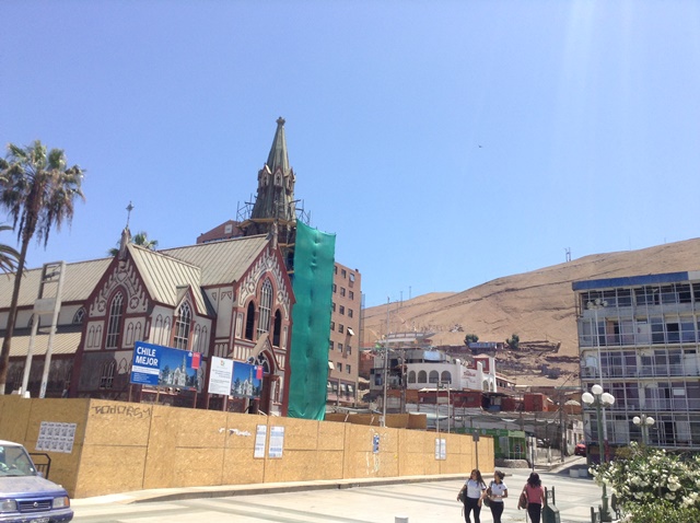


nhà thờ đang được sửa sang


Chim chóc đậu đầy trên mái nhà


CRISTOBAL COLON
(Christopher Columbus)

(Christopher Columbus)


dạo phố một tý


gặp nhân viên trên tàu


lên tới trên đỉnh của Morro de Arica


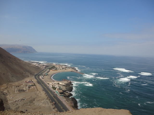


từ đỉnh Morro de Arica nhìn xuống thung lũng Azapa


dấu vết của trận chiến giữa Chí Lợi và Peru 1880 và Arica thuộc về Chile sau đó


trên đường đi chợ trái cây


đến đâu cũng muốn mua trái cây

mái lợp đơn sơ để che nắng


tour guide đang đổi tiền bản xứ Péso để trả tiền mua trái cây ($1US=700 Peso Chile)

mẵng cầu xiêm trông hấp dẫn quá


có cả mì gói


bà cụ này bán thuốc nam


đến làng thủ công nghệ


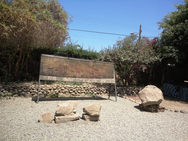


ai khòm hơn ai


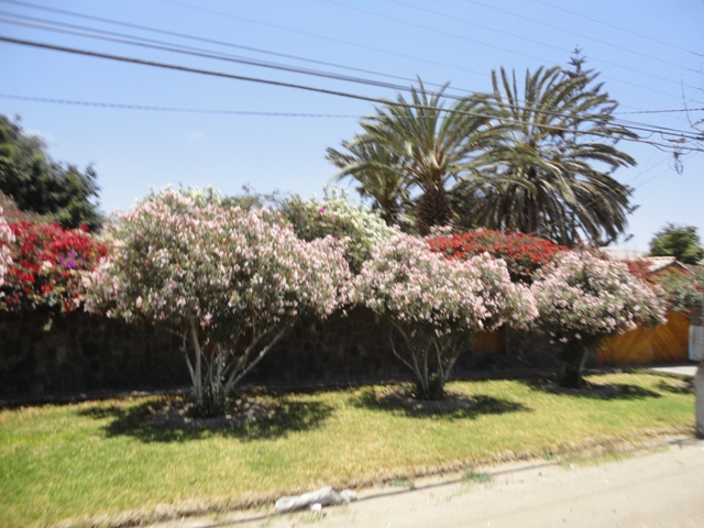
bông giấy đủ màu nở rộ khắp nơi


đến khu trồng Olivier (đặc sản của Arica)


cả chuối và hoa chuối


Arica
From Wikipedia, the free encyclopedia
For other uses, see Arica (disambiguation).
| Arica | ||||||
|---|---|---|---|---|---|---|
| City and Commune | ||||||

Montage of Arica, Morro de Arica, Presencias Tutelares 22 kms to the south Arica, Port of Arica, Cathedral of San Marcos.
| ||||||
| ||||||
| Nickname(s): "City of the eternal spring" | ||||||
| Coordinates (city): 18°29′S 70°20′WCoordinates: 18°29′S 70°20′W | ||||||
| Country | ||||||
| Region | ||||||
| Province | Arica | |||||
| Founded | 1541 | |||||
| Government[1] | ||||||
| • Type | Municipality | |||||
| • Alcalde | Salvador Urrutia (PRO) | |||||
| Area[2] | ||||||
| • Total | 4,799.4 km2 (1,853.1 sq mi) | |||||
| Elevation | 2 m (7 ft) | |||||
| Population (2012)[2] | ||||||
| • Total | 210,216 | |||||
| • Density | 44/km2 (110/sq mi) | |||||
| • Urban | 175,441 | |||||
| • Rural | 9,827 | |||||
| Sex[2] | ||||||
| • Male | 91,742 | |||||
| • Female | 93,526 | |||||
| Time zone | CLST (UTC−3) | |||||
| Postal code | 1000000 | |||||
| Area code(s) | +56 58 | |||||
| Website | Official website (Spanish) | |||||


Arica (English /əˈriːkə/ uh-ree-kuh) is a commune and a port city with a population of 196,590 in the Arica Province of northern Chile's Arica y Parinacota Region. It is Chile's northernmost city, being located only 18 km (11 mi) south of the border with Peru. The city is the capital of both the Arica Province and the Arica and Parinacota Region. Arica is located at the bend of South America's western coast known as the Arica Bend or Arica Elbow. At the location of the city two lush valleys that dissect the Atacama Desert converge: Azapa and Lluta. These valleys provides fruit for export.[3]
Arica is an important port for a large inland region of South America. The city serves a free port for Bolivia and manages a substantial part of that country's trade.[3] In addition it is the end station of the Bolivian oil pipelinebeginning in Oruro.[3] The city's strategic position is enhanced by being next to the Pan-American Highway, being connected to both Tacna in Peru and La Paz in Bolivia by railroad and being served by an international airport.
Its mild weather has made Arica known as the "city of the eternal spring" in Chile while its beaches are frequented by Bolivians.[3] The city was an important port already during Spanish colonial rule. Chile seized the city from Peru in 1880 following the War of the Pacific and was recognized as Chilean by Peru in 1929. A substantial part of African Chileans live in or trace their origins to Arica.
Contents
[hide]History[edit]
Archaeological findings indicate that Arica was inhabited by different native groups dating back 10,000 years.
Colonial period[edit]
Spaniards settled the land under captain Lucas Martinez de Begazo in 1541, and in 1570, the area was grandly retitled as "La Muy Ilustre y Real Ciudad San Marcos de Arica" (the very illustrious and royal city of San Marcos of Arica). By 1545, Arica was the main export entrepot for Bolivian silver coming down from Potosí, which then possessed the world's largest silver mine. Arica thus held the crucial role as one of the leading ports of the Spanish Empire. The envious riches made Arica the target for pirates, buccaneers, and privateers, among whom Francis Drake, Thomas Cavendish, Richard Hawkins, Joris van Spilbergen, John Watling, Simon de Cordes, Leandro de Valencia, Bartholomew Sharp, William Dampier, and John Clipperton all took part in looting the city.
Peruvian period (1821–1880)[edit]
Following the collapse of Spanish rule, in 1821, Arica was part of the recently independent Peruvian Republic. The Peruvian Constitution of 1823 regards it as a province of the Department of Arequipa.
In 1855, Peru inaugurated the Arica-Tacna railroad (53 km long), one of the first in Latin America. The rail line still functions today.
.JPG)
The earthquake of August 13, 1868 struck near the city with an estimated magnitude of 8.0 to 9.0, killing an estimated 25,000 to 70,000 people.[4] Others estimate that the population of Arica was less than 3,000 people and the death toll was around 300.[citation needed] It triggered a tsunami, measurable across the Pacific in Hawaii, Japan and New Zealand. As Arica lies very close to the subduction zone known as the Peru–Chile Trench where the Nazca Plate dives beneath the South American Plate, the city is subject to megathrust earthquakes.
Chilenization period (1880–1929)[edit]

Chilean forces occupied the region following the War of the Pacific. The Treaty of Ancón in 1883 formally acceded to Chilean control. The 1929 Tacna-Arica compromise in the Treaty of Lima subsequently restored Tacna to Peru but Arica remained part of Chile.
Modern Arica (1929–present)[edit]
In 1958, the Chilean Government established the "Junta de Adelanto de Arica" (Board of Development for Arica), which promulgated many tax incentives for the establishment of industries, such as vehicle assembly plants, a tax-free zone, and a casino, among others.[5] Many car manufacturers opened plants in Arica, such as Citroën, Peugeot, Volvo, Ford andGeneral Motors, which produced the Chevrolet LUV pickup until 2008.
In 1975, together with Chile's new open economy policies, the "Junta de Adelanto de Arica" was abolished.
The Arica and Parinacota Region was created on October 8, 2007 under Law 20.175, promulgated on March 23, 2007 by President Michelle Bachelet in the city of Arica.
Demography[edit]

According to the 2002 census by the National Statistics Institute, Arica spans an area of 4,799.4 km2 (1,853 sq mi) and has 185,268 inhabitants (91,742 men and 93,526 women). Of these, 175,441 (94.7%) lived in urban areas and 9,827 (5.3%) in rural areas. The population grew by 8.8% (14,964 people) between the 1992 and 2002 censuses. Arica is home to 97.7% of the total population of the region.[2]
The population is a mixture between older-residing local Indians such as the Aymara with African people or Chinesewho first arrived as miners and rail workers in the 1890s, and Europeans including the Spanish, Italians, Greeks, British and French or their descendants who arrived at different times of local history. Some Ariqueanos have an affinity with the cultures of Peru and distantly, Bolivia.
The urban area of Arica has 175,441 inhabitants in an area of 41.89 km². Arica in 2007 had more than 185,000 inhabitants (not counting the inhabitants of the valleys and Lluta Azapa, with that reach almost to the 194.000 inhabitants). The growing city of Arica spreads outward into the desert and the Peru-Chile border. The Azapa Valley has developed a year-round agricultural economy due to improvements in irrigation and transportation of its products.
The villages that make up the commune are Villa Frontera and San Miguel de Azapa. Some hamlets are Poconchile, Molinas, Sora, Las Maitas and Caleta Vitor.
Arica was made famous in 1970 by the spiritual master Oscar Ichazo when he held a 10-month training there for 50 Americans from the Esalen Institute in California. The Arica School, based in America, has influenced thousands of people all over the world.
The commune of Arica is composed of 19 census districts.
| Census districts of the Arica commune | |||
|---|---|---|---|
| # | District | Area (km2) | 2002 Population |
| 1 | Puerto | 1.2 | 2,744 |
| 2 | Regiment | 0.7 | 3,880 |
| 3 | Chinchorro | 13.3 | 12,816 |
| 4 | San José | 1.2 | 13,216 |
| 5 | Población Chile | 17.3 | 9,086 |
| 6 | Azapa | 1,937.8 | 14,991 |
| 7 | José Manuel Balmaceda | 2.7 | 11,984 |
| 8 | Carlos Dittborn | 2.1 | 10,525 |
| 9 | Lauca Park | 0.4 | 4,934 |
| 10 | José Miguel Carrera | 0.6 | 5,836 |
| 11 | Condell | 0.5 | 6,358 |
| 12 | Strong Citadel | 215.9 | 28,209 |
| 13 | Chaca | 794.0 | 223 |
| 14 | El Morro | 0.9 | 3,286 |
| 15 | Chacalluta | 419.3 | 1,684 |
| 16 | Molinos | 1,376.0 | 649 |
| 17 | Pedro Blanqui | 7.3 | 25,131 |
| 18 | Cancharayada | 5.3 | 17,530 |
| 19 | Las Torres | 2.9 | 11,878 |
| - | stragglers | 308 | |
| Total | 4,799.4 | 185,268 | |
Source: INE 2007 report, "Territorial division of Chile"[6]
Notable residents[edit]
- Dante Poli - former footballer
- Hipólito Unanue - physician, and briefly president of Peru
- Américo - singer
- Chañaral Ortega-Miranda (b. 1973) - classical composer
Features[edit]
| This section does not cite any sources. (March 2012) |
See also: Morro de Arica and Arica–La Paz railway


The Morro de Arica is a steep and tall hill located in the city. Its height is 139 meters above sea level. It was the last bulwark of defence for the Peruvian troops who garrisoned the city. It was assaulted and captured on June 7, 1880 by Chilean troops in the last part of their Campaña del Desierto (Desert Campaign) during the War of the Pacific.
Near the city is the Azapa Valley, an oasis where vegetables and Azapa olives are grown. Economically, it is an important port for Chilean ore, and its tropical latitude, dry climate, and the city's beach, have made Arica a popular tourist destination. It is also a center of rail communication with Bolivia and has its own international airport. Arica has strong ties with the city of Tacna, Peru; many people cross the border daily to travel between the cities, partly because many services (for example, dentists) are cheaper on the Peruvian side. Arica is connected to Tacna in Peru and to La Paz in Bolivia by separate railroad lines.
Climate[edit]
According to the Köppen Climate Classification system, Arica features the rare mild desert climate, abbreviated "Bwn" on climate maps.[7] Unlike many other cities with arid climates, Arica seldom sees extreme temperatures throughout the course of the year. Arica is also known as the driest inhabited place on Earth, at least as measured by rainfall: average annual precipitation is 0.76 mm (0.03 inches), as measured at the airport meteorological station.[8] Despite its lack of rainfall, humidity and cloud cover are high. With humidity levels similar to those of equatorial climates the sunshine intensity is similar to the Sahara desert regions in the Northern Hemisphere (like the Cape Verde islands). Oxford geographerNick Middleton's book on people who live in extreme climates, Going to Extremes (ISBN 0-330-49384-1), discusses his visit to this city.
| [hide]Climate data for Arica (1970–2000, extremes 1961–2010) | |||||||||||||
|---|---|---|---|---|---|---|---|---|---|---|---|---|---|
| Month | Jan | Feb | Mar | Apr | May | Jun | Jul | Aug | Sep | Oct | Nov | Dec | Year |
| Record high °C (°F) | 31.0 (87.8) | 31.5 (88.7) | 31.2 (88.2) | 28.8 (83.8) | 26.6 (79.9) | 25.9 (78.6) | 24.0 (75.2) | 24.2 (75.6) | 23.2 (73.8) | 27.0 (80.6) | 26.8 (80.2) | 29.0 (84.2) | 31.5 (88.7) |
| Average high °C (°F) | 25.8 (78.4) | 26.2 (79.2) | 25.6 (78.1) | 23.6 (74.5) | 21.4 (70.5) | 19.4 (66.9) | 18.3 (64.9) | 18.3 (64.9) | 19.0 (66.2) | 20.4 (68.7) | 22.2 (72) | 24.1 (75.4) | 22.0 (71.6) |
| Daily mean °C (°F) | 22.7 (72.9) | 23.0 (73.4) | 22.1 (71.8) | 20.2 (68.4) | 18.3 (64.9) | 17.0 (62.6) | 16.1 (61) | 16.1 (61) | 16.7 (62.1) | 17.8 (64) | 19.4 (66.9) | 21.1 (70) | 19.2 (66.6) |
| Average low °C (°F) | 19.8 (67.6) | 19.8 (67.6) | 18.9 (66) | 17.1 (62.8) | 15.5 (59.9) | 14.8 (58.6) | 14.3 (57.7) | 14.5 (58.1) | 15.0 (59) | 15.8 (60.4) | 16.9 (62.4) | 18.2 (64.8) | 16.7 (62.1) |
| Record low °C (°F) | 10.0 (50) | 14.6 (58.3) | 12.4 (54.3) | 10.2 (50.4) | 6.8 (44.2) | 5.8 (42.4) | 6.2 (43.2) | 6.2 (43.2) | 8.0 (46.4) | 9.0 (48.2) | 9.9 (49.8) | 7.0 (44.6) | 5.8 (42.4) |
| Average precipitation mm (inches) | 0.3 (0.012) | 0.2 (0.008) | 0.2 (0.008) | 0.1 (0.004) | 0.2 (0.008) | 0.2 (0.008) | 0.1 (0.004) | 0.1 (0.004) | 0.0 (0) | 0.0 (0) | 0.1 (0.004) | 0.0 (0) | 1.5 (0.06) |
| Average precipitation days | 0.3 | 0.2 | 0.1 | 0 | 0.1 | 0.3 | 0.3 | 0.3 | 0.3 | 0 | 0 | 0.1 | 2 |
| Average relative humidity (%) | 72 | 72 | 72 | 74 | 76 | 77 | 77 | 77 | 77 | 75 | 73 | 72 | 75 |
| Mean monthly sunshine hours | 263.5 | 240.1 | 269.7 | 219.0 | 192.2 | 144.0 | 120.9 | 120.9 | 156.0 | 201.5 | 228.0 | 251.1 | 2,406.9 |
| Mean daily sunshine hours | 8.5 | 8.5 | 8.7 | 7.3 | 6.2 | 4.8 | 3.9 | 3.9 | 5.2 | 6.5 | 7.6 | 8.1 | 6.6 |
| Source #1: Dirección Meteorológica de Chile,[9] Universidad de Chile (sunshine hours only)[10] | |||||||||||||
| Source #2: Latin American Climate Assessment & Dataset (extremes 1961–2010),[11][a] [1] | |||||||||||||
Administration[edit]
As a commune, Arica is a third-level administrative division of Chile administered by a municipal council, headed by an alcalde who is directly elected every four years. The 2008-2012 alcalde is Waldo Sankán Martínez (Independent).[1]
Within the electoral divisions of Chile, Arica is represented in the Chamber of Deputies by Mr. Vlado Mirosevic (Partido Liberal) and Mr. Luis Rocaful as part of the 1st electoral district, which includes the entire Arica and Parinacota Region. The commune is represented in the Senate by Fulvio Rossi Ciocca (PS) and Jaime Orpis Bouchon (UDI) as part of the 1st senatorial constituency (Arica and Parinacota Region and Tarapacá Region).
Sports[edit]
Arica was one of the four host cities of the 1962 FIFA World Cup, and it was the venue for a Rip Curl Pro Search surfing event that took place from June 20 to July 1 in 2007. Arica Plays host to a leg of the International Bodyboarding Association's world tour event every year at the notorious "el flops" surf break. The event has been running since 2004.
Tourist attractions[edit]
- Morro de Arica: the prominent mount rising above the city, affording sweeping views.
- Catedral de San Marcos de Arica: the magnificent church designed by Gustave Eiffel was built in the 1870s.
- Plaza Colón: the civic heart of the city, the public square is where its residents congregate for celebrations, diversions or just being a part of the community.
Other attractions include the former house of the Governor, the House of Culture, railway station Arica-La Paz, the Archaeological and Anthropological Museum of San Miguel de Azapa, Sea and Historical Arms and Arica. For evening entertainment there is the Casino de Arica.
Beaches[edit]
More than 20 km of beaches, and across the Coastal Range in the northern sector, which makes them and different from other cities in Chile in terms of topography.
From north to south the beaches are located Las Machas, Chinchorro, del Alacrán, El Laucho, La Lisera, Brava, Arenillas Negras, La Capilla, Corazones and La Liserilla.
Other tourist sites[edit]

.jpg)
- Chungará Lake: Arica is the main access road to the lake, the 29th highest in the world (and the 10th highest in South America)[2], with an approximate height of 4517 metres. It is located within the Lauca National Park.
- Pucará de Copaquilla: about 3,000 metres above sea level, dates from the 12th century, declared National Monument, located on a promontory that serves as the defence has a double stone wall, which protects a series of internal spaces. From this point it is possible to observe the pre-and streams.
- Termas de Jurasi a few miles southeast of Putre, by Ruta 11-CH, turning off a dirt road. Underground waters are home to temperatures above 40 °C (104 °F) which are reputed to have medicinal properties.
- Surf Arica is a world-famous spot for surfing. The wave known as "El Gringo" hosts surfing and bodyboarding world championships every year. In 2007, Arica was the site for an ASP world tour contest. Others stops on this tour include Hawaii, Tahiti, Fiji and South Africa.
Transport[edit]
In 2011, Chile announced plans to privatise the Port of Arica. These were opposed by Bolivia, as Arica is its main sea port.[12]
Chacalluta International Airport is the main airport in Arica and is located 18.5 km to north of the city. In this terminal operates three domestic airlines, LAN Chile, Principal Airlines and Sky Airlines to many Chilean airports and also toArequipa, Peru and La Paz, Bolivia.
*******************************
Arica (Chili)
| Arica San Marcos de Arica | ||||||||||||
Héraldique |  Drapeau | |||||||||||
 | ||||||||||||
| Administration | ||||||||||||
|---|---|---|---|---|---|---|---|---|---|---|---|---|
| Pays | ||||||||||||
| Région | Région d'Arica et Parinacota | |||||||||||
| Province | Province d'Arica | |||||||||||
| Maire | Waldo Sankán Martínez | |||||||||||
| Code postal | 1000000 | |||||||||||
| Indicatif téléphonique | +56 | |||||||||||
| Démographie | ||||||||||||
| Gentilé | Ariqueño/a | |||||||||||
| Population | 200 000 hab. (2009) | |||||||||||
| Densité | 42 hab./km2 | |||||||||||
| Géographie | ||||||||||||
| Coordonnées | 18° 28′ 28″ Sud70° 18′ 01″ Ouest | |||||||||||
| Altitude | 2 m | |||||||||||
| Superficie | 479 940 ha = 4 799,4 km2 | |||||||||||
| Divers | ||||||||||||
| Fondation | ||||||||||||
| Localisation | ||||||||||||
Géolocalisation sur la carte : Chili
| ||||||||||||
| Liens | ||||||||||||
| Site web | http://www.muniarica.cl | |||||||||||
| modifier | ||||||||||||


Arica est une ville portuaire du nord du Chili située dans le désert d'Atacama. C'est la capitale de la province d'Arica, dans la région d'Arica et Parinacota.
Elle a une population de 200 000 habitants en 2009 et est connue comme la « ville de l’éternel printemps ».
Sommaire
[masquer]Histoire[modifier | modifier le code]
Arica a été le théâtre de l’un des plus célèbres épisodes de la Guerre du Pacifique (1879-1884), la prise du Morro de Arica en 1880. Jusqu’à cette époque, la ville faisait partie du Pérou.
Par ailleurs Arica abrite le stade Estadio Carlos Dittborn qui fut l'un des 4 stades où se disputèrent les matchs de la phase finale de la Coupe du monde de football de 1962.
Climat[modifier | modifier le code]
Arica est aussi connue comme l'endroit habité le plus aride au monde, selon les mesures de pluviométrie : les précipitations moyennes annuelles sont de 0,8 mm1. Entre 1903 et 1918, il n'y a pas eu une goutte de pluie durant 173 mois.
Économie[modifier | modifier le code]
Près de la ville se trouve la vallée d’Azapa, une oasis où des légumes et olives d’Azapa sont cultivés. Économiquement, c’est un port important, tandis que son climat doux et très sec ainsi que ses plages ont fait d’Arica une destination touristique populaire. C’est également un centre ferroviaire de communications avec laBolivie. Elle possède un aéroport international (Chacalluta, -code AITA : ARI).
Presse[modifier | modifier le code]
Jumelage[modifier | modifier le code]
 Bressuire (France) depuis 1997
 Artigas (ville) (Uruguay)
Arica dans la culture populaire[modifier | modifier le code]
- Dans Battlefield Bad Company 2, la ville est le théâtre (fictif) d'une bataille (Port d'Arica ou Arica Harbor en anglais). Il y a plusieurs points de réapparitions basés sur la ville :
- Déploiement de l'attaquant (où en approchant du poste frontière on peut lire sur un panneau "Welcome to Chile")
- Poste Frontière (du Pérou au Chili)
- Ville
- Ville près du pont (où il y a un pont comme son nom l'indique)
- Dernier Effort (dernier point de réapparition de l'attaquant, également l'un des points de réapparitions situés au port d'Arica avec le dernier point de réapparition des défenseurs)
Pour plus d'information voir sur le site officiel du jeu ou sur l'article de Wikipedia qui lui est dédié (Battlefield: Bad Company 2).


